By Al Dutcher, Nebraska Associate State Climatologist
Nebraska has had few storms since an early February event brought blizzard conditions and a significant swath of snow from southwest through northeast Nebraska. Total accumulations of the moisture-laden snow ranged from 6-15 inches with a sharp drop off on the southern flank where totals dropped to 1 inch over a 40-mile span.
Since then the eastern United States has been dominated by a strong upper air trough and temperatures in eastern Nebraska have struggled to warm sufficiently to melt off the deep snow pack. During the past week, this weakening trough has allowed the warmer and drier air mass over the western half of the state to finally work eastward. With calving season well underway this recent respite from storm activity has benefitted ranchers. However, predictions are for a shift to more stormy conditions across the central and western Plains in March.
It is not unusual to experience an extended lull in storm activity during the heart of an El Nino winter as storm activity influenced by the southern jet remains south of the region. Conversely, the northern jet has begun to have a more meaningful influence on the eastern U.S. as the current El Nino begins to weaken.
Planting and Early Season Forecast
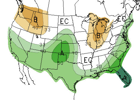
It is entirely possible that our recent lull in storm activity will be short lived if the most recent El Nino advisories and Long Lead Outlooks verify this spring. Climate Prediction Center (CPC) outlooks indicate a continuation of the trend of above normal moisture from the southwest U.S. through the central Plains. This has been the dominant forecast for our region since last November.
The CPC indicates that the deep upper air trough over the eastern US appears to be weakening in the short term, which would allow more storm activity in the western US. They feel this energy may also bring increased storm activity to the central and southern Plains in March and beyond.

For the third consecutive CPC release below normal moisture is forecast across the eastern Corn Belt in April through June with above normal moisture across the central Rockies. This would suggests that El Nino will likely impact North American weather through spring and early summer.
As expected, the El Nino signal indicates above normal temperatures in the 30- and 90-day periods for the northern, western, and eastern US. Below normal temperature are confined to Texas, New Mexico, western Oklahoma, southwest Kansas, and southeastern Colorado. However, above normal temperatures are forecast for all of the contiguous US from June through August. This would indicate increasing confidence that the forecast will verify.
How Long Will El Nino Stay?
The ultimate question on when this El Nino event will end remains an open question. Figure 4 shows that the dynamic model consensus of the most recent CPC El Nino advisory shows dissipation of the signal between the April-June and May-July periods. It should be noted that the dynamic model average (yellow) and the statistical model average (light green) begin to diverge in the May-July period.
The divergence between the statistical and dynamic models predicts the onset of La Nina conditions during the late summer (dynamic) to just shy of La Nina conditions by the September-November period. Since the western Corn Belt shows a drier tendency to La Nina conditions during the late summer and early fall, a verification of the statistical models would favor drier conditions developing at the end of the growing season compared to the second half of the summer (dynamic models).
Considerable uncertainty still exists regarding when this El Nino will end. Shorter term outlooks continue to portray the same spring trends that first appeared in the December forecast. Therefore, the most likely scenario expected this spring is for drier than normal conditions in the eastern Corn Belt and wetter than normal conditions in the western Corn Belt.
Signals are mixed for what weather to expect in the second half of 2016. Most of the uncertainty is associated with when this El Nino is officially declared over and whether we’ll see La Nina develop before the growing season ends. The consensus of CPC dynamical models indicates La Nina will begin before the end of the growing season; statistical models say it won’t. We will watch next month’s release to see if the divergence in models continues or they return to similar projections for the summer and early fall.


